
VORTEX FdC
- Home
- Companies
- VORTEX FdC
- Software
9 software found
VORTEX FdC software

Vortex TIMES - Wind Data for Energy Production Assessment
Vortex TIMES is a detailed wind dataset that provides long-term, high-resolution 10-minute time series for any specific location. It includes key meteorological variables for wind resource assessment, such as wind speed, wind direction, and wind standard deviation. The dataset covers up to 30 years and includes all heights from 10 to 440 meters above ground level. It can also be calibrated with on-site measurements to reduce uncertainty. Vortex TIMES helps assess energy production more accurately, understand site variability, and explore how different factors like turbulence, wind shear, and atmospheric stability interact.
Vortex BLOCKS - Gridded Time Series and WRG files
Vortex BLOCKS is a GIS file, a WRG file, a TAB file, and it is a sub-hourly time series at any grid point. All of them can be obtained by filtering through different variables such as time of day, season, or stability. Vortex BLOCKS is the natural evolution of FARM. It has the same modeling technology that has been used in hundreds of projects and is extensively validated, but it goes a step beyond.
Vortex MAST - Wind Distribution
Vortex MAST is designed to support the crucial decision of where to install a real met mast in the field. For a small fraction of the cost of a physical mast, it provides valuable insights to help you compare and select the most promising candidate sites. Simulated at 100-meter spatial resolution, Vortex MAST offers detailed wind information for each location, including the wind speed distribution, a Weibull fit, and outputs in TAB format, along with a concise report. This high-resolution, pre-mast assessment helps reduce uncertainty early in the development process and guides smarter investment decisions.
Vortex LES - One-year Wind Turbulence Time Series
Vortex LES delivers a one-year, high-resolution time series that includes detailed turbulence information, making it ideal for microscale wind energy applications. Based on the WRF model developed by NCAR’s Mesoscale and Microscale Meteorology (MMM) Laboratory, Vortex LES uses a Large Eddy Simulation (LES) approach to resolve turbulent eddies directly—providing a level of detail that closely resembles real measurements. Vortex has been a pioneer in applying WRF-LES for microscale downscaling since 2016, offering one of the most realistic modelled datasets on the market. In this approach, traditional turbulence parameterizations in WRF are replaced by LES physics, seamlessly integrating meso- and microscale dynamics in a single modeling chain.
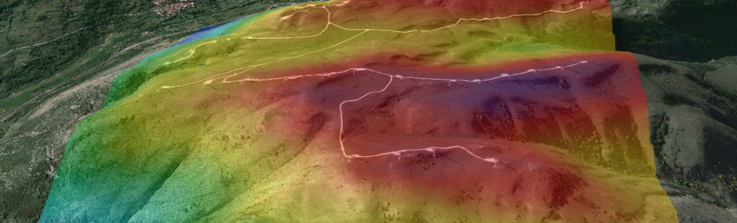
Vortex FARM - Wind Resource Grid (WRG) Files
The Vortex FARM product is a high-resolution map ready to use when the wind farm area is already selected, but not yet the turbine locations or their class. It has been developed to support AEP analysis, wind farm layout design, and site suitability impact studies, facilitating the decision-making process at the wind farm pre-construction stage. Vortex FARM includes long-term statistics at all heights within an area, plus high-resolution temperature, mean wind speed, extreme wind speed (Vref), and turbulence intensity maps, having the ability to be calibrated with measurements.
Vortex EXTREMES - Wind Speed Modeling
Vortex EXTREMES provides key data on extreme wind speed events to support safer, more cost-effective wind farm design. It allows for statistical calibration with observations to adjust maximum wind speeds. The methodology follows a two-step approach: first, a low-resolution mesoscale simulation identifies 6 major extreme wind events per year over a 30-year period (180 total), enabling fast, affordable candidate selection. Then, WRF-LES is used to simulate these events at high resolution, resolving turbulence and local effects with enhanced accuracy. This process delivers precise estimates of yearly maximum 10-minute wind speeds using one of the most advanced modeling techniques available.
Vortex SERIES - Hourly Meteorological Data Set
Vortex SERIES provides a multidecadal (up to 30 years) hourly time series that seamlessly integrates with your Measure-Correlate-Predict (MCP) process. With sufficient local measurements, you can extend short-term observations into reliable long-term projections with precision. This dataset includes hourly meteorological variables such as wind speed, wind direction, temperature, and relative humidity, available at heights ranging from 10 to 300 meters. Moreover, Vortex SERIES is designed to be fine-tuned and calibrated with your specific measurement data, ensuring the best possible accuracy.
Vortex MAPS - Regional Wind Resource Mapping
Vortex MAP will provide you with the regional wind resource in a large area in the prospection phase of the wind farm development.