
- Home
- Companies
- TatukGIS Sp. z o. o.
- News
- Rooftop Solar Project Planning Software
Rooftop Solar Project Planning Software
Geospatial software development company, Idan Computers, has used the TatukGIS Developer Kernel in C++Builder to develop an interesting new solution to streamline the planning of solar energy projects for residential and industrial rooftops. The Idan Solar Panels Planner (ISPP) is a complete solution from start to finish, providing tools to efficiently survey a site by aerial drone, generate an accurate 3D model from oblique imagery to simulate shading patterns and seasonality using solar geometry, plan the placement of panels, generate all necessary construction drawings, and precisely compute the project's energy yield and return on investment (ROI) in real time. Results of highly accurate, per panel, electricity yield computations are provided in clear and detailed monthly reports. Planning time can be reduced from hours or days to less than an hour, enabling vendors to quote projects faster and with greater confidence. ISPP is suitable for projects ranging from single residential to utility-scale complexes.
The Idan Solar Panels Planner streamlines the planning process into a few easy steps.
1. Survey by Autonomous Drone Flight. The project site is surveyed by autonomous drone flight, requiring zero manual intervention. This eliminates need for manually performed rooftop measurements, saving time and eliminating risk of errors. ISPP is compatible with just about any off-the-shelf commercial drone products that take images. The Software guides the drone around a predefined structure or area on a flight path that ensures comprehensive oblique image coverage, with each image referenced to a coordinate space. The drone flight typically takes 2 - 3 minutes. Images are transferred by cable to the ISPP software on a laptop computer.
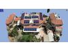
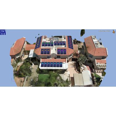
2. Generate 3D Model. With the single push of a button, oblique images captured by the drone are mathematically transformed into a detailed, geospatially correct, 3D dimensionally accurate model that is used to place the panels and precisely calculate the influence of shadow patterns on each panel as the sun tracks across the sky. Every nearby building, rooftop, tree, and fence that could have a shading influence is mapped and analyzed. All measurements are true. Requiring only a few minutes to generate, the 3D model becomes the foundational base for all planning and simulations.
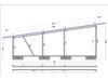
3. Design the Project. Intuitive and largely automated design tools (not requiring advanced expertise or extensive training) are used to generate the rooftop panel layout (see above image), component selections, and detailed technical drawings of each structural element providing all necessary measurements and specifications to guide the physical installation. With three user clicks, the ISPP software can place dozens of panels. Manual editing tools are available to place, move, lift, duplicate, etc. panels. Energy yield simulations for each design iteration are performed in real time.
4. Yield Computations Using Solar Geometry. For each project configuration, the ISPP software simulates a highly accurate prediction of the kilowatts of electricity generated by each panel in each hour of every day over the lifetime of the project, the project's ROI, and quantity of carbon saved from the atmosphere. Idan's proprietary Solar Analysis Engine precisely tracks the sun path across the sky, sunrise to sunset and season by season, while performing complex trigonometric calculations to incorporate the azimuth positioning, tilt angle, and orientation of each panel. The Software quantifies the effects of constantly changing 3D shading patterns on each individual panel, ambient irradiation, panel size and specifications, efficiency degradation over time, panel specific temperature effects and other microenvironmental factors, and local weather patterns using the European Commission’s PVGIS database of 5-year averaged hourly meteorological data. Energy yield simulations involve 4,300+ annual calculations per panel, one calculation for each daylight hour in the year. A full solar project analysis is computed in approximately 3 minutes. Detailed reports transparently break down the monthly electricity output of the project and each panel.
Many aspects of the Idan Solar Panels Planner are derived from the TatukGIS Developer Kernel (DK), a comprehensive GIS development kit, including drone flight planning and tracking, image georeferencing, coordinate system handling and conversions, interaction with geospatial data, complicated geometric analyses, and measurements. The DK GisSunPosition method (one of roughly 20,000 DK supported methods and properties) provides the sun position relative to any map location for any date and time. Learn more about TatukGIS SDK products at: www.tatukgis.com
Serving government, military, law enforcement, and civil engineering customers worldwide since 1971, Idan Computers is known for pioneering oblique imaging technology and for CARTA, the first commercial contouring software based on a triangulation algorithm. Since 2005, Idan has used the TatukGIS Developer Kernel as the GIS foundation for all its geospatial development projects. Learn more about Idan and its ISPP product at: www.idan.com