

- Home
- Companies
- GecoSistema Srl
- Products
- Model Small Hydro Power ATLAS -SHPA - ...
Model Small Hydro Power ATLAS -SHPA -User-Friendly Spatial Decision Support System
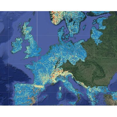
PAN-EU Small HydroPower Atlas (SHPA) is an user-friendly spatial decision support system for run-of-river hydropower plants feasibility and development across EU. The product innovation consists in making feasibility assessment much quicker and affordable, which may be a critical aspect in the development of small plants.
- Estimate HP productivity based on river flow, hydraulic jump and environmental constraints
- Rank sites for development of SHP plants, considering limiting factors such as infrastructures presence
- helps to identify sites where hydropower development is both suitable and economically feasible
- Once located a potential site, screen for costs and optimal sizing of the plant
- Compare different sites and solutions
Available across EU, SHPA web spatial decision support system takes into account hydrological, technical and economic factors and provides data and indicators for preliminary feasibility analysis.
- Individual hydropower project developers and investors: assess (ex-ante) the expected average production and help to select suitable location for new plants
- Public Authorities: Assess the average production for environmental permit or taxation purposes, or environmental impact assessment (EIA)
- Users’ groups or professional associations: Calculate expected production in broader terms as a benefit for the members
- Producers of the HP equipment: Advertisement and/or part of the user maintenance services
Do you want to invest and make profit in small hydropower plants?
SHPA will assist you in selecting the site that suits your needs and perform a fast and reliable technical, environmental and economical assessment.
The service is powered by a modelling framework able to take into account the average flow regime under current and future climate conditions, and in connection with the seasonal river flow forecasts, also short- to medium term production of HP. The pre-calculated GIS layer were obtained processing the following open data with custom routine written in Python (GDAL):
- JRC CCM River and Catchment Database, version 2.1 (CCM2)
- EEA EU-DEM @ 25 m, Digital Elevation Model
- EEA Natura 2000 sites database
- SMHI E-Hype – Discharge Time-series
- EEA Corine land cover 2000-2006
- JRC European Settlement Map
The product is developed on the basis of available topographic data, flow duration curves, connectivity level to existing electric grid. The amount of water available for hydropower production also considers the need to release environmental flows to the streams.